
Every year, fatal crashes take place across Louisiana’s roadways. Sometimes, it only takes witnessing the aftermath of one tragic crash to make a stretch of road stick in your mind as somewhere to be extra cautious. While personal experiences shape how drivers view these routes, data allows us to measure the danger more precisely.
For those affected by serious collisions, consulting a Baton Rouge car accident attorney can provide valuable insight into the legal and financial aspects of the recovery process.
To identify Louisiana’s most deadly road segments, we analyzed five years of fatal crash data from the National Highway Traffic Safety Administration (NHTSA), covering 2019 through 2023. We mapped these crashes onto overlapping 10-mile segments along interstates and major highways, then ranked them based on the number of fatal collisions.
Read on to see which road stretches ranked among the most fatal in Louisiana.
Quick Links
- Map of Louisiana’s Deadly Highway Stretches
- I-10 & I-12 Dominate the Deadliest Road Stretches in Louisiana
- Methodology
- Frequently Asked Questions
- Fair Use Statement
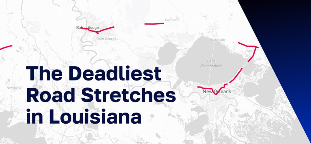
[Interactive Map] Louisiana’s Deadly Highway Stretches
The map below is interactive; zoom in and hover over each stretch to reveal more information.
I-10 & I-12 Dominate the Deadliest Road Stretches in Louisiana
Below is our ranking for the road stretches in Louisiana with the highest number of fatal crashes between 2019 and 2023. Each stretch indicates fatal crashes and fatality counts, along with the nearest city where the segment is located. For more details on the specific start and end points, a written overview of each stretch by the nearest city follows below.
New Orleans
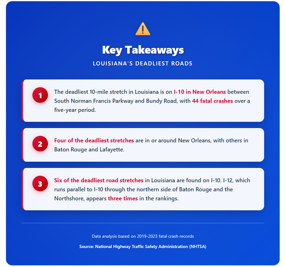
New Orleans accounts for four of the nine most deadly highway segments in Louisiana, all located along I-10. The most fatal stretch statewide is a 10-mile portion of I-10 between South Norman Francis Parkway and Bundy Road, where 44 fatal crashes and 46 deaths were recorded over five years.
This stretch passes through Mid-City and provides access to major destinations such as the French Quarter, University Medical Center, Mardi Gras World, Smoothie King Center, Caesars Superdome, and the New Orleans Lakefront Airport.
A second deadly stretch runs through Jefferson Parish, from Williams Boulevard to South Cortez Street, ranking third overall with 17 fatal crashes. While technically outside New Orleans proper, it lies just west of the city and remains a key part of the metro’s roadway system.
Another high-risk corridor appears within Orleans Parish, running from Wright Road to the Frank Davis Memorial Bridge, with 14 fatal crashes, tying for sixth place.
St. Tammany Parish (Northshore)
Two deadly segments fall within St. Tammany Parish, part of the Northshore region northeast of New Orleans. A segment of I-12, just north of Lake Pontchartrain but still within the broader New Orleans metro, makes the list. This stretch, from North Military Road to the Frank Davis Memorial Bridge, had 14 crashes and 15 fatalities, tying for fourth place.
Another stretch on I-12, ranked ninth. It runs from Big Branch Bayou near State Route 434 to I-59, recording 13 fatal crashes over the five-year period.

Baton Rouge
The Baton Rouge area also features prominently in the rankings. The second-deadliest stretch statewide is on I-12, running east from I-10 to the Corporal Shawn Kelly Memorial Boulevard exit, with 29 fatal crashes and 32 deaths.
This segment begins at the I‑10/I‑12 split, a major interchange known for congestion, lane weaving, and heavy vehicle volume. Along this 10-mile corridor, key exits like Essen Lane (Exit 1B/C) provide access to Our Lady of the Lake Regional Medical Center, one of the largest hospitals in the state.
Another Baton Rouge segment appears in eighth place: a 10-mile stretch of I-10 between North Lobdell Highway and Essen Lane, with 13 fatal crashes and 14 fatalities.
This stretch also provides access to Our Lady of the Lake Regional Medical Center. It serves as a key commuter route, linking LSU’s campus, the Highland Road neighborhoods, and downtown Baton Rouge to the eastern suburbs. Daily backups during peak hours are common, as several Reddit users have described.
One more Baton Rouge-adjacent stretch straddles Livingston Parish, continuing toward Hammond. Located on I-12, ahead of South Frost Road towards Pumpkin Center Road, this corridor recorded 13 crashes and 17 deaths, placing seventh.
Lafayette
The only road segment in southwest Louisiana to make the top list is found in the Lafayette metro area. Located on I-10 between Louisiana Avenue and Grand Point Highway in St. Martin Parish, this 10-mile stretch tied for fourth place, with 14 fatal crashes and 15 deaths.
Methodology
This analysis is based on data from the Fatality Analysis Reporting System (FARS) by the National Highway Traffic Safety Administration (NHTSA). We collected all fatal crashes across Louisiana’s road network between 2019 and 2023.
Fatal crashes were mapped, and using a rolling window approach, we scanned the highways in 10-mile segments to find the stretches with the highest concentration of fatal crashes. These were identified and ranked by crash totals, with total fatality count used as a tiebreaker.

Frequently Asked Questions
Why are I-10 and I-12 so dangerous?
I-10 and I-12 are particularly dangerous due to a combination of factors, including high traffic volume, heavy commercial truck traffic, complex interchanges, congestion during peak hours, and challenging weather conditions. Six of Louisiana’s deadliest road stretches are on I-10, while I-12 appears three times in the rankings.
The I-10/I-12 split in Baton Rouge is a major interchange known for lane weaving and heavy vehicle volume, making it especially hazardous. Common causes of accidents on these highways include distracted driving, speeding, following too closely, impaired driving, and unsafe lane changes.
How can I stay safe while driving on these dangerous roads?
To reduce your risk of an accident on Louisiana’s deadliest highways, follow these safety guidelines:
- Stay alert and minimize distractions—put your phone away
- Maintain a safe following distance, especially in heavy traffic
- Use extra caution at major interchanges like the I-10/I-12 split
- Plan travel during off-peak hours when possible to avoid congestion
- Be aware of weather conditions and adjust your speed accordingly
- Watch for commercial trucks and give them extra space to maneuver
- Use your turn signals well in advance when changing lanes
- Stay in the right lane unless passing
- Never drive impaired or fatigued
- Plan your route ahead of time to avoid last-minute lane changes
Even when following all safety precautions, accidents can still happen due to other drivers’ negligence.
What should I do immediately after a crash on I-10 or I-12?
If you’re involved in a crash on I-10, I-12, or any Louisiana road or highway, take these immediate steps:
- Check for injuries and call 911 immediately
- Move to safety if possible, but don’t leave the scene
- Call the police to file an official accident report
- Document the scene with photos and videos if you’re able
- Gather information from other drivers and witnesses
- Seek medical attention even if you don’t think you’re seriously injured
- Contact a car accident lawyer before speaking to insurance companies
These steps protect both your health and your legal rights to compensation. Avoid giving recorded statements to insurance adjusters without first consulting an attorney.
How long do I have to file a claim after a Louisiana highway accident?
In Louisiana, you typically have two years from the date of the accident to file a personal injury claim, as outlined in Louisiana Civil Code Article 3493.1. However, there are important exceptions to this deadline. For example, if the accident involves a government entity or vehicle, you may have a much shorter deadline to file a notice of claim.
It’s critical to consult with an experienced Baton Rouge car accident attorney as soon as possible after your accident to ensure you don’t miss any important deadlines that could prevent you from recovering compensation.
What compensation can I recover after a highway accident?
After a Louisiana highway accident, you may be entitled to recover both economic and non-economic damages, including:
Economic Damages:
- Medical expenses (past and future)
- Lost wages and loss of earning capacity
- Property damage
- Rehabilitation and therapy costs
- Home modifications if disabled
Non-Economic Damages:
- Pain and suffering
- Emotional distress
- Loss of enjoyment of life
- Loss of consortium (for spouses)
The amount you can recover depends on the severity of your injuries, the strength of your case, and the insurance coverage available. Under Louisiana’s modified comparative fault law (effective January 1, 2026), you can recover compensation as long as you are 50% or less at fault for the accident.
Fair Use Statement
You are welcome to reference or share this analysis. If you do, please include a link to the original report so others can access the full dataset and methodology.